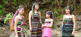
 Ratanakiri is located in Cambodia's far northeast bordered by Laos to the north, Vietnam to the east, Mondulkiri to the south, and Stung Treng to the west. This rural rugged province is a 70% ethnic minority, which are known as "Chunchiet". Ratanakiri was as recently as 2002 seriously off the beaten track but has since been "discovered" step by step. Still, while you won't get any bragging rights for coming here, it's well worth the effort to do so, and once you get away from it's capital Banlung you won't run into too many other tourists. So Ratanakiri is still a remote province in Northeastern Cambodia worth to visit. The word "Ratanakiri" itself is a derivative of two Cambodian words, which are combined to mean "place of gems and mountains." The word comes from the Sanskrit words Ratna (gem) and giri (mountain). It's quite dusty capital, Banlung, is located in the central highlands of the province, approximately 365 miles (586 kilometres) from Phnom Penh and reminds one of a wild western city, even if it's the wild east. Its wide red laterite roads are bordered by new, recently build houses replacing the older ones. The centre of the town features a lively marked with all the needful things. Lomphat is a small town in the southern plains, which was once the former capital of Ratanakiri. There are a few other small towns like Ta Veng and Voen Sai. The province is getting more and more popular for thousands of tourist every year. Especially for those, who seek a close contact to originality, hidden roots of ethnic groups and abundant wildlife. Therefore the Ecotourism abounds, due to lush wildlife and remote tribal villages. Most of the inhabitants of Ratanakiri are indigenous minorities.
Ethnic Cambodians make up only 10-20% of the country's total population. Remnants of an ancient volcano exist near to Banlung in the form of a crystal-clear lake that was formed after the active volcano went dormant. There are also a few ancient lava fields that testify to the fact that the area was quite lively at one time. Beautiful waterfalls, clear rivers winding through stretches of jungle, and rolling hills that meet mountains near the Vietnamese and Lao border provide a full agenda for nature lovers. Non-structured, low-impact, custom trips to outlying villages and natural areas can be organized (strictly by yourself or with help from a guesthouse).
Ratanakiri is located in Cambodia's far northeast bordered by Laos to the north, Vietnam to the east, Mondulkiri to the south, and Stung Treng to the west. This rural rugged province is a 70% ethnic minority, which are known as "Chunchiet". Ratanakiri was as recently as 2002 seriously off the beaten track but has since been "discovered" step by step. Still, while you won't get any bragging rights for coming here, it's well worth the effort to do so, and once you get away from it's capital Banlung you won't run into too many other tourists. So Ratanakiri is still a remote province in Northeastern Cambodia worth to visit. The word "Ratanakiri" itself is a derivative of two Cambodian words, which are combined to mean "place of gems and mountains." The word comes from the Sanskrit words Ratna (gem) and giri (mountain). It's quite dusty capital, Banlung, is located in the central highlands of the province, approximately 365 miles (586 kilometres) from Phnom Penh and reminds one of a wild western city, even if it's the wild east. Its wide red laterite roads are bordered by new, recently build houses replacing the older ones. The centre of the town features a lively marked with all the needful things. Lomphat is a small town in the southern plains, which was once the former capital of Ratanakiri. There are a few other small towns like Ta Veng and Voen Sai. The province is getting more and more popular for thousands of tourist every year. Especially for those, who seek a close contact to originality, hidden roots of ethnic groups and abundant wildlife. Therefore the Ecotourism abounds, due to lush wildlife and remote tribal villages. Most of the inhabitants of Ratanakiri are indigenous minorities.
Ethnic Cambodians make up only 10-20% of the country's total population. Remnants of an ancient volcano exist near to Banlung in the form of a crystal-clear lake that was formed after the active volcano went dormant. There are also a few ancient lava fields that testify to the fact that the area was quite lively at one time. Beautiful waterfalls, clear rivers winding through stretches of jungle, and rolling hills that meet mountains near the Vietnamese and Lao border provide a full agenda for nature lovers. Non-structured, low-impact, custom trips to outlying villages and natural areas can be organized (strictly by yourself or with help from a guesthouse).
Beung Yeak Laom is located in Yeak Loam commune, Ban Loung district, about 5 kilometers south of Ban Loung provincial town. A lake in the middle of a mountain, it was formed many centuries ago from a volcano. The lake is about 800 meters in diameter and 48 meters deep during the dry season. The water is clear and suitable for swimming. There are two places along the bank where visitors can relax and enjoy a panoramic view of the lake and the flora and fauna. A tourist information center is on the west bank, and handicrafts made by hill tribes living nearby are available for sale.
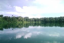 It is a place of worship for the hill tribes. They believe there is a powerful spirit who owns the surrounding land and forest. Beung Yeak Laom is popular with tourists who like to swim or hike in the forest surrounding the lake. Because there are no vendors, visitors should bring along their own food and beverages. It is the natural lake, which locates at the middle of mountain in Yeak Loam Commune, Ban Lung district from the Ban Lung town. The lake has square shape, approximate 800m diameter and 48m depth during the dry season, and occurs by volcano for centuries. The lake has clear water as the sea suitable for swimming, and there are tow harbors protruded to the above of the water for tourists to view the scenary and birds that are swimming along the stretch of the forest surrounding the lake. information to tourists, and also for displaying souvenirs and handicrafts made by ethnic minorities. At the western bank of the lake, there is a tourist information center where for guiding and giving information center where for guiding and giving information to tourists, and also for displaying souvenirs and handicrafts made by ethnic minorities. Beung Yeak Laom is located in Yeak Laom commune, Ban Loung district, about 5 kilometers south of Ban Loung provincial town. A lake in the middle of a mountain, it was formed many centuries ago from volcano. The lake is about 800 meters in diameter and 48 meters deep during about dry season. The water is clear and suitable for swimming. It is a natural, almost square-shaped lake situated in the middle of a mountain in Ban Lung District, 5km from Rattanakiri provincial town. The lake is approximately 800m in diameter with a depth of 48m during the dry season, and was created by volcanic movements centuries ago. Boeung Yak Loam has picturesque mountainous scenery, a charming bird sanctuary and provides the visitor with an opportunity to experience the daily life of local hill-tribe people.
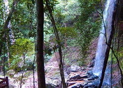
Kachang Waterfall is situated 6km. north - west of Banlung. This Waterfall is located in the Kontung stream and flows into the Sre Pok River.
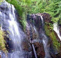 The height of it is 12 m. and the water flows and falls throughout the year. A beautiful or magnificent landscape and huge amounts of fresh mist surround the waterfall. The visitors can take a bath and sit to look at the waterfall and other natural scenic beauties. or the visitors can also go around to view other natural sights on foot or take an elephants ride.Kachang Waterfall is situated 26 km, South of Banlung. This Waterfall has 4 floors and the height of each floor is 4 m. The water flows throughout the year. Around the Waterfall are beautiful natural landscapes and the visitors can go take a bath if they wish.
We went to see 3 waterfalls in total, visiting Ka Tieng, Kinchaan and Chaa Ong. To get to Ka Tieng. we had to go through a small river with the bike, which was pretty nerve racking, but worth the effort. On to Kinchaan, where we met some local guys keen to show off their cliff jumping skills, although i was happy to remain dry after my last cliff jumping experience ended in hospitalisation, with a torn medial knee ligament. I was happier to get wet at Chaa Ong, where Julia and I took a dip in the powerful spray dropping around 10 metres. We headed back to Ban Lung at sunset, impressed by the waterfalls and happy i had coped on the motorbike.Ka Tieng waterfall is located in Labang I commune, Lum Phat district, about 7 kilometers southeast of Ban Loung provincial town. Ka Tieng is below Ka Chanh waterfall and about 3 kilometers from it. Closeby to yesterdays posted waterfall of Ka Chanh is the Katieng (or Ka Tieng) waterfall in Ratanakiri province, Cambodia.
 So close that both can be visited within an hour of Ratanakiri?s provincial capital of Banlung. Again take the road out of town west for 2 km then roughly 3,5 km to the south just beyond a school is a dirt track veering off to your right. Keep following this track past cashew nut plantations (with the possibility of taking an elephant) until the road descends over a rutted track. In all from the turn it?s about 1,5 km. From the food stalls it is pretty obvious that you have arrived though the road proper fords the stream and continues onwards. A small entrance fee is required. Above the 10 m high fall is a large park like area. Off to the left is a trail that leads to a staircase to the huge pool below well worth a great swim.
Ka Tieng waterfall is in the middle of lush forest at the Lbang I commune, Lumpart district, 7 kilometers south-west of Banlung Town. The name of Ka Tieng is originally got from Kreung hill tribe in Ka Kieng village. The waterfall is about 10 meters high, which is flows and falls throughout the year. Visitors will feel release with the huge clear waterfall and a beautiful natural landscape around the area. Around the waterfall, there is forest full of big and small trees projecting the cool shadow suitable for resting, viewing the water falling down and having picnic here. The Katieng Waterfall, Ratanakiri is one of the less visited waterfalls in the area. You can enjoy some wonderful time if you combine your visit to this waterfall with an elephant ride. Elephant rides are available from the elephant village of Phume Kateung, north of the falls. You can also see the Katieng Waterfall, Ratanakiri from flights, if you are lucky. When the plane is landing or taking off, watch out for the falls. Elephant rides to this falls are available for an hour and a half. These can be organized by the lodges you are staying in.
So close that both can be visited within an hour of Ratanakiri?s provincial capital of Banlung. Again take the road out of town west for 2 km then roughly 3,5 km to the south just beyond a school is a dirt track veering off to your right. Keep following this track past cashew nut plantations (with the possibility of taking an elephant) until the road descends over a rutted track. In all from the turn it?s about 1,5 km. From the food stalls it is pretty obvious that you have arrived though the road proper fords the stream and continues onwards. A small entrance fee is required. Above the 10 m high fall is a large park like area. Off to the left is a trail that leads to a staircase to the huge pool below well worth a great swim.
Ka Tieng waterfall is in the middle of lush forest at the Lbang I commune, Lumpart district, 7 kilometers south-west of Banlung Town. The name of Ka Tieng is originally got from Kreung hill tribe in Ka Kieng village. The waterfall is about 10 meters high, which is flows and falls throughout the year. Visitors will feel release with the huge clear waterfall and a beautiful natural landscape around the area. Around the waterfall, there is forest full of big and small trees projecting the cool shadow suitable for resting, viewing the water falling down and having picnic here. The Katieng Waterfall, Ratanakiri is one of the less visited waterfalls in the area. You can enjoy some wonderful time if you combine your visit to this waterfall with an elephant ride. Elephant rides are available from the elephant village of Phume Kateung, north of the falls. You can also see the Katieng Waterfall, Ratanakiri from flights, if you are lucky. When the plane is landing or taking off, watch out for the falls. Elephant rides to this falls are available for an hour and a half. These can be organized by the lodges you are staying in.
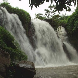
Cha Ong waterfall is in the forest in Cha Ong village, O'Chum commune, about 2 kilometers west of Ban Loung provincial town. It was given its name by the Kreung hill tribe living nearby.The waterfall gets its water from Phnom Eysei Patamak or Phnom Svay near Ban Loung provincial town. From its upper level, the water flows from a small canal before dropping 25 meters to a lower level. A mountain slop leads visitors to the bottom of the waterfall, where they can sit inside a cave and enjoy the view. The waterfall gets its water from Phnom Eysei Patamak or Phnom Svay near Ban Loung provincial town from its upper level, the water flows from a small canal before dropping 25 meters to a lower level.
 A mountain slop leads visitors to the bottom of the waterfall, where they can sit inside a cave and enjoy the view.Ka Chanh waterfall is located in Ka Chanh commune, Ban Loung district, about 6 kilometers southeast of Ban Loung provincial town. The waterfall is 12 meters high and is fed year round by the OKan Teung canal.
From the waterfall the water flows into Sre Pork River in Lum Phat district. The waterfall was given its name by the Kreung ethnic minority in Ka Chanh village.There are a number of scenic rubber plantations along the canal leading to the waterfall. The base of the waterfall, which is a lovely place for picnic, can be reached by climbing down are also available.We call the waterfall 'Cha Ong' because we follow the ethnic minority of Kreung at Cha Ong village closed to the waterfall.
The source of this waterfall is from the mountain named 'Ey sey Pak Ta Mak' or called 'Phnom Svay' closed to the Ban Lung town. The situation from above is a small canal which continuously flows through the broken rocks, then to the stream below in 25-kilometer height. To view the waterfall, we should go down to the stream below where we have seen a big rocky cave with plain roof. At the bottom of the stream, there are many big rocks used as the seats for viewing the great and interesting water falling down from the mountaintop.
A mountain slop leads visitors to the bottom of the waterfall, where they can sit inside a cave and enjoy the view.Ka Chanh waterfall is located in Ka Chanh commune, Ban Loung district, about 6 kilometers southeast of Ban Loung provincial town. The waterfall is 12 meters high and is fed year round by the OKan Teung canal.
From the waterfall the water flows into Sre Pork River in Lum Phat district. The waterfall was given its name by the Kreung ethnic minority in Ka Chanh village.There are a number of scenic rubber plantations along the canal leading to the waterfall. The base of the waterfall, which is a lovely place for picnic, can be reached by climbing down are also available.We call the waterfall 'Cha Ong' because we follow the ethnic minority of Kreung at Cha Ong village closed to the waterfall.
The source of this waterfall is from the mountain named 'Ey sey Pak Ta Mak' or called 'Phnom Svay' closed to the Ban Lung town. The situation from above is a small canal which continuously flows through the broken rocks, then to the stream below in 25-kilometer height. To view the waterfall, we should go down to the stream below where we have seen a big rocky cave with plain roof. At the bottom of the stream, there are many big rocks used as the seats for viewing the great and interesting water falling down from the mountaintop.
.jpg "Independent Monument")
.jpg "Royal Palace")
.jpg "Angkor Wat")
.jpg "Bayern")
.jpg "Ochheuteal Beach")
.jpg "Sokha Beach")


.jpg "Rabbit Island")
.jpg "Kep Beach")

